[Type text] [Type text] [Type text]
Urban Growth and Decline
Table of Contents
31. Where it isâ¦
2. Maps 4
2.1 Annandale within Sydney 4
2.2 Annandale Zoning Map 5
2.3 Photo Locations 6
3. Changes in Annandale 7
3.1 Residential 7
3.2 Commercial 7
3.3 Community 7
4. Why it has changed 8
5. Future of Annandale 8
Bibliography 9
�
�
1. Where it isâ¦
Annandale is located 5 kilometers West of the Central Business District (GPO) of Sydney within the Inner Western Suburbs. Annandale's northern end lies on Rozelle Bay, which is on Sydney Harbour. Glebe lies to its east, Lilyfield and Leichhardt to its west and Stanmore to its south.
It is well connected via a tram line and buses. It was established in 1823 and has a postcode of 2038.
It's coordinates are:
33ð52â²53â³S
151ð10â²15â³E
�
�
2.2 Annandale Zoning Map
�
2.3 Photo Locations
3. Changes in Annandale
3.1 Residential
The main changes in Annandale are residential changes, namely being renovations and modifications, as seen in 3.1
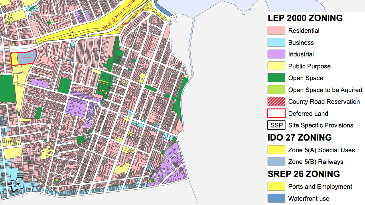 Figure 1
 Figure 2
 Figure 3
and 3.2 in the process of gentrification. However the LGA, Municipality of Leichhardt is strictly controlling all development, attempting to maintain the heritage of the area. This has resulted in a blockade of development, leading to urban degradation. Matters have even been disputed in court over developments that have resulted in a small number of modern houses nestled within the Victorian houses. Another significant change is the development of Harold Park, which will lead to a mass of new apartments and land.
3.2 Commercial
Annandale has also undergone commercial changes. There have been multiple renovations of shops on Booth Street, the center of Annandale Village, as well as plans for larger developments, such as a Woolworths on the corner...