Describe the geographical processes associated with the natural hazard:Tropical cyclones may affect four Australian states. The two most commonly affected states are Queensland and Western Australia. The Northern Territory is affected by cyclones very occasionally. New South Wales on very rare occasions may feel the affects of a cyclone. The majority of Australian cyclones form off the NW coast of Australia in the Indian Ocean, or off the NE coast in the Coral Sea . The Arafura Sea off the NW of the Northern Territory may also see the formation of cyclones but not to the same degree as the latter two areas.
Australia's most famous cyclone, Cyclone Tracy did form in that area. The only other area that cyclones form is in the Gulf of Carpentaria. It is formed by a natural force called El Ninò which pushes Tropical Cyclone development further eastwards in the Coral Sea / Pacific ocean.
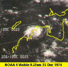 This picture shows Cyclone Tracy near landfall on ...
 Damaged houses after the passage of Cyclone Tracy ...
 Devastation brought by Cyclone Tracy upon the Nort...
This means that it has less affect over the semi enclosed waters of the Gulf of Carpentaria.
New South Wales is the only other state to see Cyclones. For NSW they are a rare visitor and usually have weakened by this stage. The Northern Rivers and Mid North Coasts are affected more by flooding rains rather than destructive winds. Once a cyclone moves this far south there is often severe isobar compression between it and high pressure cells to the south. This leads to a vigorous onshore feed that can bring inches of rain. A broad band of strong to gale force winds also develops leading to large ocean swells that can cause problems.
The entire Queensland coastline is open to tropical cyclones. Generally the more stronger destructive cyclones cross the Queensland coast between Cooktown and Rockhampton. The coast between Townsville and Mackay is particularly at risk because of...