SynopsisThis photo study seeks to provide an overview analysis of the Kosciuszko Alpine Area. It focuses on the effects of glaciation and running water on the lithosphere, the interactions of the spheres and provides a short overview analysis of the vegetation. Photos are included as evidence and to aid in an explanations of the topics. All grid references are for Kosciuszko Map Extract.
ContentsPageTitle Page1Synopsis + Contents2Introduction3Thredbo Climate Graph + Maps4Section A6Section B8Section C10Bibliography + Appendix12IntroductionThe Kosciuszko Alpine Area (KAA) is a unique and beautiful place and is located in the South-East region of Australia across New South Wales and Victoria. Our fieldwork has focused on the area along the Four Wheel Drive track from Charlottes Pass to Blue Lake and Caruthers Peak. The path provides examples of the habitats and environments of the Kosciuszko Alpine Area, such as Heath, Tall Alpine Herbfield, Windswept Feldmark etc ÃÂ and photos provide a record of each of the different habitats.
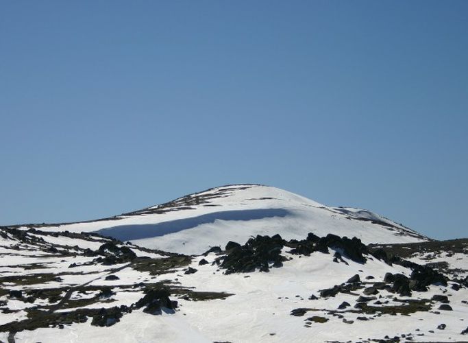 Mount Kosciuszko from the east
 Kaas
Kaas Kaas plateau - Zen Garden
The Kosciuszko Alpine Area is one of the worldÃÂs oldest mountain ranges but following millions of years of erosion it has undergone dramatic weathering. For example, the effects of glaciers appears smaller in the KAA than in many other alpine regions around the world. It is also home to one of the most delicate ecosystems in the world and contains many types of flora and fauna that are exclusive to the area. Importantly, it remains the only glaciated area in mainland Australia.
StatisticsJanFebMarAprMayJunJulAugSepOctNovDecAnnualYearsTemperatureMean maximum temperature (ðC)21.121.018.113.910.16.65.26.69.613.216.219.113.43519692008Mean minimum temperature (ðC)7.06.84.51.4-0.4-2.4-4.0-2.5-0.61.73.65.21.73419692008RainfallMean rainfall (mm)105.384.5104.6107.8153.4165.2158.2187.5212.9182.6160.6119.01712.43619692008Decile 5 (median) rainfall (mm)100.380.895.197.6141.8159.5136.9182.5205.5173.2145.7126.71753.73519692008Mean number of days of rain âÂÂ¥ 1 mm8.98.18.49.110.712.312.613.314.111.711.48.9129.53519712009Thredbo Climate GraphMapsSection A: The effect of glaciation on the lithosphere of the KAA, and the subsequent effect of running water on the landscapeIn the KAA there are numerous examples of the effects of glaciations and running water (also known as fluvial features). A prominent example of any glacier is the U-shaped valley that is left behind once the glacier has melted. With fluvial features there are usually V-shaped valleys where the water has cut away the sides leaving a V-shape. Parts of the Snowy are V-shaped valleys and it is often easy to recognise the difference between a glacial feature and a fluvial feature.
During the field trip many examples of glaciations in the KAA were noted. The most prominent example of glaciation was the area at Blue Lake which is a cirque that has been formed by a glacier millions of years ago. The glaciers appear to have started at Blue Lake and then moved with the force of gravity. Glaciers carve out U-shaped valleys by ÃÂgrindingÃÂ the earth down like sandpaper and overtime cuts a path through the ground and as it travels, picking up large boulders that help in the ÃÂsand paperingÃÂ process. Evidence of the glacier at Blue Lake can be identified by the large moraines at the side of Blue Lake that show the start of glacier (highlighted on the field sketch of Blue Lake on the next page). The glacier then appears to follow a path which has created a U-shaped valley as it travelled. Another example of a glacial feature in the KAA is the U-shaped valley in Section A Photo 1. This is a clear example of where a glacier finished and has left a large deposit of rocks and soil that had been pushed along similar to the effect from a bulldozer. As glaciers carry rocks they also deposit them once they are pushed to the side or when the glacier has melted. This is often why you will see large boulders that seem out of place resting in an area with no other visible rocks. There examples of glaciation are prominent at the KAA but not as obvious as they are in other countries around the world in higher regions. While the impact of glacial movement has been signficant, when contrasted with other areas in North America the outcomes are small in comparison.
An important feature in the area is also found in the evidence of the fluvial features, particularly in parts of the Snowy River where fluvial features with the clear V-shaped sides created by the constant flow of water carried away much of the soil. V-shapped valleys are formed by flowing rivers because they erode more soil downwards than laterally This causes the bottom to erode quickly while the sides erode more slowly which leads to what can often be steep sides of the river. Section A Photo 2, shows a small V-shaped valley found at the KAA and while the small creek is only a tributary to the Snowy River, it still has caused enough erosion to form the V-shape. The v-shaped valleys in the region are relatively small but are still good examples of the effects of running water.
In conclusion, water has changed the shape of the KAA dramitically over the years through both glaciation and running water. The examples studied provide a good indication of the variety of effects and changed landscapes that are the result of glaciation and running water .
Section B: Interactions of the spheres, and how this contributes to the major facets of the ecosystem: landforms, vegetation, soil and climateInteractions between the spheres occur all around the world. The spheres are the Biosphere which contains all living things and the Lithosphere is the outer layer of the earth which covers everything from mountain ranges to the sea floor. The hydrosphere contains all water in all its forms (eg Ice, vapour and liquid) and the atmosphere is the air surrounding the earth. These spheres react in different ways with each other that can generate both positive and negative results.
An example of a simple interaction between two spheres is the formation of U and V-shapped valleys. These formations are explained in greater detail in Section A. The interactions in these examples highlight the differences between the lithosphere and the hyrdosphere.
Another interaction between the spheres is the Mountain Plum Pine where the spheres interacting in this instance are the litosphere and the biosphere. Mountain Plum Pine is the only tree that survives above the treeline in the KAA. The vegetation only manages to survive by growing on boulders which create their own microclimate which then provides enough heat for the Mountain Plum Pine to survive, even in the extremes of cold. The microclimate works during the day through the sun heating up the outer layers of the rocks which is the source of heat that the Mountain Plum Pine uses in order to survive.
The boulders at Mount Kosciuszko offer another interaction and that is their exfoliation which involves the lithosphere and the atmosphere. Exfoliation occurs when the heat from the sun heats the outer layers of the boulders causing it to expand, which then cools at night as there is no heat from the sun. With this constantly occurring almost everyday it causes major stress leading to the outer shell of the rocks ÃÂpeeling offÃÂ, not unlike an onion.
Weathering also occurs in the boulders due to the effect known as ÃÂfreeze thaw actionÃÂ. This occurs when water seeps into the cracks of the rock and then freezes at night. As water expands it creates massive stress on the boulder leading to larger cracks in the rock which eventually leads to the rock splitting apart, which is an interaction between the hydrosphere and the lithosphere.
There are many examples of interactions between the spheres all around the world and the KAA is no exception. These interactions range from the weathering of rocks through to the survival of trees above the tree line. The spheres are important and no life could survive with out them.
Section C: Vegetation associations of the KAAThere are many types of flora in the KAA and many are exclusive to the area. The flora in the KAA can be categorised as Heath, Tall Alpine Herbfield, Short Alpine Herbfield, Windswept Feldmark , Bogs and Fens. Each of the vegetations categories maintains different flora and requirements.
Bogs and Fens GR 175 686Water is important to all ecosystems around the world and this is especially the case in the the higher cold climate regions of the KAA. At certain points in rivers in the KAA you can find bogs and fens. These act as a filter or ÃÂliverÃÂ for area. The KAA has high levels of rainfall yet most of the plants are also drought resistant. The reason for being so drought resistant in an area with such high rainfall is that the. bogs and fens only cover six percent of the area yet they are also critical in maintaining water purity in the area. The most common plant in the Bogs and Fens is the Sphagnum Moss (see photo in apendix).
Tall Alpine HerbfieldGR 180 675Tall Alpine Herbfield covers 68 percent of the KAA with many of the plants in the Tall Alpine Herbfield area being drought resistant. There are a variety of plants that live in the Tall Alpine Herbfield including Poa (Section C Photo 3), Celmisia (Section C Photo 1), Craspedia and Alpine Celery.
Heath GR 173 693Heath covers 25 percent of the KAA and is usually found around the outside of bogs where the soil is often damp. Heath is used to describe the plant communities in the KAA that have small leaves and wooden stems and generally low lying. The Mountain Plum Pine lives in the Heath (Section B Photo 1) along with plants such as the Golden Shaggy-pea and the Reddish Bog Heath.
Short Alpine Herbfield GR 170 696Short Alpine Herbfield is rare in the KAA and only covers 0.85 percent of the area. They are usually found in areas below the snowline and where the soil is permanently wet. The Short Alpine Herbfield resembles grass, almost even a putting green. This ÃÂgrassÃÂ is not actually grass but is Small Star Plantain. The other plants found in the Short Alpine Herbfield are the Star Plantain (see photo in appendix).
Windswept Feldmark GR 163 699Windswept Feldmarks cover 1.6 percent of the KAA and are found on the slopes that are the least protected. These areas have high wind speeds which blow away and snow and dry out and moisture from the precipitation leaving this area very dry even with 2,500mm of rainfall per year. The snow that does fall here is blown away leaving the area exposed for the plants which use snow as an insulator. Section C Photo 2 is of the Windswept Feldmark found on the track before Mt Twynam. There are not many plants that can survive in the difficult conditions of the Windswept Feldmark. The plants that do survive manage to by remaining low lying with small, dense leaves and curving away from the wind. The plants found in the Windswept Feldmark include the Coral Heath, Silver Ewartia, Horey Sunray and the Anemone Buttercup. The plants in the Windswept Feldmark are known to migrate downwind by a few millimetres per year. This occurs because the upwind side of the plant dies and the downwind sides continue growing.
BibliographyAnonymous, ,Maps, http://www.maps.ethz.ch, Accessed at Canberra on 14th MarchMy Kosciuszko Alpine Area Field Notebook.
Bureau of Meteorology, Thredbo Weather Report, Bureau of Meteorology, Accessed at Canberra on 14th March
 Kaas Blues .....
 English: Tal-y-llyn glacial valley at Dolgoch, Gwy...
 An U-Shaped valley in Norway.