Location Burundi is in Central Africa, just east of Democratic Republic of the Congo, south of Rwanda, and west and south of Tanzania. It is landlocked between those countries with a total border length of 974 kilometers. Its geographic coordinates are 3 30 S, 30 00 E. Brazil, Malaysia, and New Zealand are at about the same latitude as Burundi. At the same longitude is Turkey and the very western point of Russia. Burundi is a bit smaller than Maryland with a total area of 27,830 sq km.
Place-Physical Burundi is the edge of the watershed of the Congo and the Nile rivers, while the Ruzizi River in the west flows along the Great Rift Valley. The lowest point is Lake Tanganyika at 772 meters above sea level. The highest point in Burundi is Mount Heha at 2,670 meters. Lake Tanganyika is 670 meters long and the deepest point is 1,460 meters.
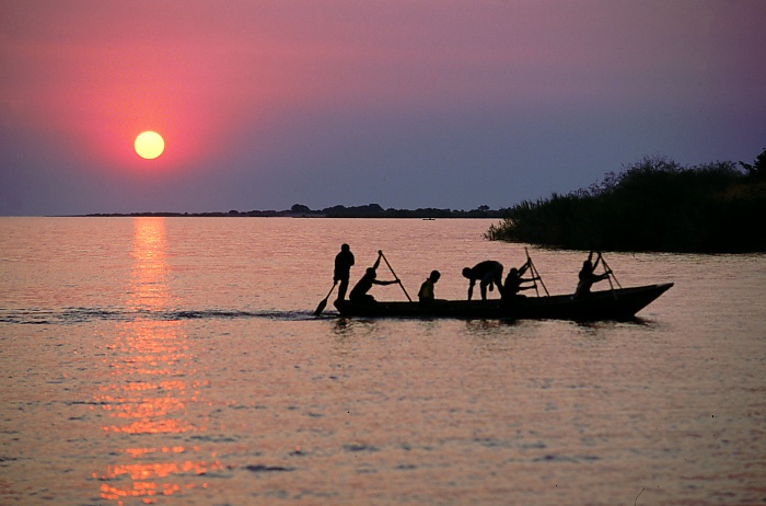 English: Fisherman on Lake Tanganyika, Mishemba Ba...
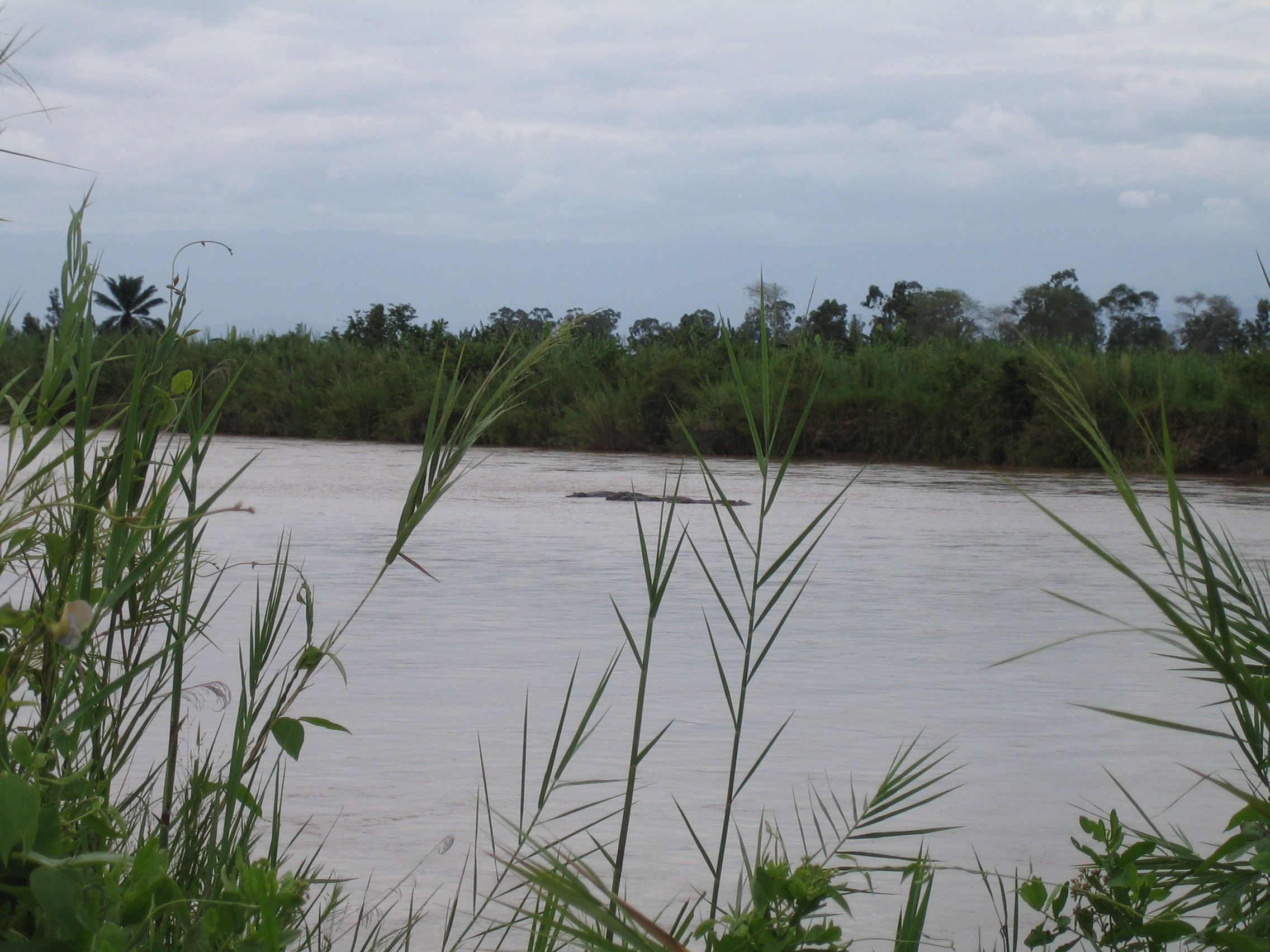 Hippopotami in the Ruzizi River in Burundi
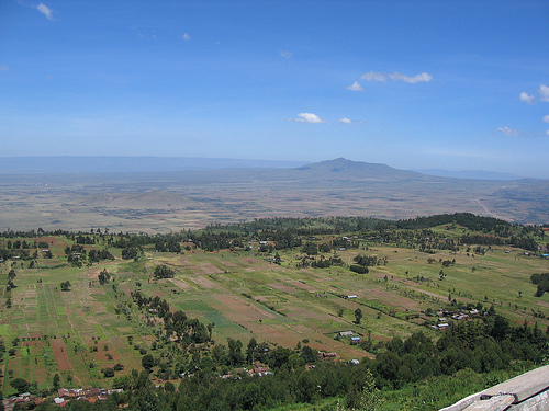 Rift Valley
It is the second largest of African lakes, the second deepest (next to L. Baikal) and the longest lake of the world. It holds 240 native species. The average water temperature is 23 degrees Celsius. The area is 32,000 kilometers square. Mount Heha is the 21st highest mountain in Africa, and 89th in the world.
Burundi lies on the Great African Plateau formed by the Nile and Zaire River basins. There are three regions; the Rift Valley is called Imbo, and it is along the western border. The eastern zone is Kumoso and the 3rd is the Central Mountain Region. The Rift Valley is a narrow plain that runs along the Rusizi River and the shores of Lake Tanganyika, stopping in the foothills on the western Zaire and Nile River divides.. The Rift Valley is all below 3,500 feet above sea level. The Komoso is formed by central and eastern plateaus. The elevation is about 6,000 feet. There are also savannas along the eastern border, where the average elevation is 3,400 feet. The central mountain region is formed by a group of ridges running north to south that is 16 kilometers wide and 8,000 feet high. The eastern part of the ridges in south central Burundi becomes the waters of the Rwanda River, a source of the Nile.
Although Burundi is located within 50 degrees of the equator, none of its regions is extremely hot. Burundi's climate is different than the Zaire basin because its higher elevations cause moderate temperatures. The central plateau haspleasant weather, with a temperature averaging 68 F. The Imbo region is warmer, with an average temperature of 77 F. The higher elevations of the eastern plateau are cooler, with temperatures below 66 F. The eastern savannas are hotter reaching 73 F. June, July, August, January and February are dry months. A long wet season lasts from March to May; a short wet season is September to December. Rainfall is uncommon, with most rain in the northwest area. Rainfall on the plateaus averages 119.4 centimeters, dropping to 76.2 centimeters annually in lower areas. Violent rainstorms are frequent at the higher elevations.
Burundi once had forests covering many of the higher elevation areas, but it has mostly been cut down to allow for farming. Some of it was also intentionally burnt to enrich the soil. Deforestation has resulted in gulleying, severe surface erosion, and the rapid destruction of the topsoil. Natural vegetation survives only in Burundi's lowest areas. The shore plain of Lake Tanganyika remains forested savanna. The shores of the country's rivers and lakes are covered with bamboo and swamp plants.
Place-Human As of this year, the population of Burundi is 6,373,002. The population is broken down to 46.5% 0-14 years old, 50.7% 14-64 years and the remaining 2% are above 65 years old. The population grows about 2.5% every year. This is partially affected by AIDS, which 11% of the population has been infected with. Surprisingly, the population is 95% males and the life expectancy for a person just born is 46 years. The average woman will have 6 children in her life. The main ethnic groups are Hutu (Bantu) 85%, Tutsi (Hamitic) 14%, Twa (Pygmy) 1%, Europeans 3,000, South Asians 2,000 . The biggest religions are Christian 67% (Roman Catholic 62%, Protestant 5%), indigenous beliefs 23%, Muslim 10% and the languages spoken are Kirundi (official), French (official), Swahili (along Lake Tanganyika and in the Bujumbura area) Only 35% of the population above 15 years old can read and write any of these major languages.
The Republic of Burundi, commonly referred to as Burundi and formerly Urundi's capital city is Bujumbura. The country is divided into 16 provinces, Bubanza, Bujumbura, Bururi, Cankuzo, Cibitoke, Gitega, Karuzi, Kayanza, Kirundo, Makamba, Muramvya, Muyinga, Mwaro, Ngozi, Rutana and Ruyigi. They gained independence from being a United Nations trusteeship ruled by Belguum on July 1st 1962. That is now there independence day, the only national holiday in Burundi. The constitution was written March 13 1992 and provided a plural political system. It was modified on June 6th 1998 by a Transitional Constitution that enlarged the National Assembly and created two vice presidents to keep power equal between multiple people. There is no age of suffrage so anyone has the same legal rights as an adult except when this is prevented by cultural standards. The current chief-of-state is President Pierre Buyoya. He was elected in November of 2001, as an intermediate president for 18 months, then his vice president is to transfer to the higher position. The two major political parties are Unity for National Progress and Burundi Democratic Front. A multiparty system was installed in 1998 allowing for several smaller parties to hold some positions in the government. The flag is a rectangle divided by a white diagonal cross into red panels (top and bottom) and green panels (hoist side and outer side) with a white disk superimposed at the center bearing three red six-pointed stars outlined in green arranged in a triangular design (one star above, two stars below).
Burundi is a resource poor country because of inability to export and manufacture. Over 90% of the population is dependent on subsistence farming. Its economic health depends on the coffee crop, which accounts for 80% of foreign earnings. The ability to pay for imports rests on the climate and the international coffee market. In recent years, battle between ethnic groups has begun, killing 200,000 people and injuring 4 times that. Only 25% of the children can go to school. Food, medicines, and electricity remain in short supply, but $800,000,000 in pledges to the country have been placed and that could lead to some improvements in major cities. The GDP of the country is under $4 billion, and the average family makes $600 annually. About 70% of the population lives in poverty. The major industries are light consumer goods such as blankets, shoes, soap; assembly of imported components; public works construction; food processing. About 99% of the electricity is hydro generated. The exports are coffee, cotton, tea, corn, sorghum, sweet potatoes, bananas, manioc (tapioca); beef, milk, hides to the US, Europe, Kenya and Switzerland. Burundi owes $1.2 billion to other countries.
Human-Environment Interaction The people of Burundi must depend completely on their environment because of how reliant their economy is on agriculture and the lakes. Also they rely on subsistence farming. They have to plan their lives around the weather, flooding of the rivers and the temperature. One way they have been able to adapt to the environment and modify it is by exploiting the large lakes and generating hydroelectricity. They have also had to cut down forests to plant crops, because of the high population density. They also make use of the land's natural resources by exporting as much as they can.
Movement In Burundi there are 20,000 telephone lines in use and 16,000 cell phones. It is a primitive, open-wired telephone system. There is one earth satellite station in the Indian Ocean used by Burundi. Five radio stations serve the country's 440,000 radios and 1 television station broadcasts to 25,000 people. There is 1 government sponsored Internet Service Provider and 2,000 citizens connected to the internet. The country has no railroads and 14,480 kilometers of highway. The only waterway used for transportation is Lake Tanganyika and there also one port in the capitol city. There are seven airports, but only 1 has a paved runway. Since many of the export partners are nearby, they can be transfered by water through the Lake, but for exports to Europe and Asia it requires the involvement of other countries sometimes.
Region Burundi is its own region because of physical boundaries. It is surrounded by Lake Tanganyika, mountains, high-elevation ridges, and it is completely covering a plateau. It also has interesting climate. Because of its widely varying elevations it only has moderate temperatures, unlike other countries that close to the equator. The area also has its own political history from being ruled by European countries to being a forced member of the United Nations.
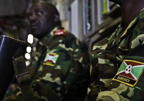 Burundi soldiers arrive in Central African Republi...
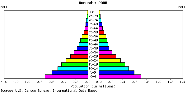 Population pyramid
 Demographics of Burundi, Data of FAO, year 2005 ; ...