Canada, is the world's second largest country and it is the largest country in the Western Hemisphere. It comprises all of the North American continent north of the United States, with the exclusion of Alaska, Greenland, and the tiny French islands of St. Pierre and Miquelon. Its most easterly point is Cape Spear, Newfoundland and its western limit is Mount St. Elias in the Yukon Territory, near the Alaskan border. The southernmost point is Middle Island, in Lake Erie and the northern tip is Cape Columbia, on Ellesmere Island.
Canada is bounded on the north by the Arctic Ocean, on the west by the pacific Ocean, and on the east by the Atlantic Ocean and its associated bodies of water, including Baffin Bay and the Labrador Sea.
Canada has an abundance of mineral, forest, and water-power resources. The mining industry has been a major force in Canada's economic development in the past and is still the main force in the advance and economic activity and permanent settlement into the northlands.
 Romania, Germany, Canada, Hungary
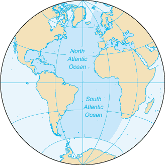 North and South Atlantic Ocean
 Uruguay, Argentina, Canada, USA
The principal minerals are petroleum, nickel, copper, zinc, iron ore, natural gas, asbestos, molybdenum, sulfur, gold, and platinum; in addition extensive beds of coal, potash, uranium, gypsum, silver, and magnesium are found.
Fresh water covers an estimated 756 276 sq km or 7.6% of Canada. The many rivers and lakes supply ample fresh water to meet the nation's needs for its communities and for irrigation, agriculture, industries, transportation, and hydroelectric power generation. Canada has four principal drainage basins: the Atlantic Basin which drains to the Atlantic Ocean by way of the Great Lakes and the St. Lawrence River, the Hudson Bay Basin which drains northward into Hudson Bay via the Churchill, Nelson and Saskatchewan rivers, the Arctic Basin which is drained by the Mackenzie River and the Pacific Basin which...