A plot plan, or site plan, shows the location of the house on the site. It also shows utilities, topographical features, site dimensions, and any other buildings on the property. Other elements that might be seen on a plot plan are the contour of land, elevation of property corner and contour lines, meridian arrow, any landscaping, streets, sidewalks, driveways, location of utilities, easements of utilities and drainage, well, septic tank, fences, retaining walls, lot number or address, and the scale of the drawing. A site plan only shows property and utilities. It doesn't show proposed construction, however, a plot plan does.
Property lines define the site boundaries. The length and bearing of each line must be identified. Property line lengths are measured with an engineer's scale to the nearest 1/100 foot.
Bearing angles are recorded in degrees, and if required, in minutes and seconds. If a property line begins or ends on a bench mark it will have a special symbol.
 Septic Tank: Illustration shows how an underground...
 The same tank partially installed in the ground
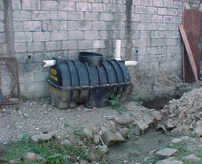 A septic tank before installation
Utilities are shown on the plan to warn of any easements which may have effect on how you plan to layout your home. Drainage is another concern to look for.
A contour is a line connecting points which have the same elevation. They help describe the topography of a site by depicting the shape and elevation of the land. Topographical features are represented by symbols and colors. The colors black, blue and green. Black representing any works of man, green is for vegetation, blue shows any tracings of water.
The location of structure on site comes with many different requirements to take into consideration. Such as, natural contour, trees, view, surrounding houses, code restrictions, style of house to be built, solar orientation, winds, placement of well and septic tank, if needed, and size and shape of the...