Abstract.
The aim of this study is to investigate the effects of 'Inverse Distance Weighted' interpolation and 'Ordinary Kriging' on a discrete spatial data set. By interpolating the discrete data points with three different techniques observations have been made on the resultant raster surface produced.
The test data used for this is a 300m2 surveyed area of the Waiotahi Valley east of Tauranga, the various prediction models highlight the difference visually and statistically and answer to a degree the question of which is the most effective.
The realisation was made that the best fitting model for the data was statistically an eight sector ordinary krige with the spherical model, visually the assessment was different; the IDW single sector surface proved to be the best.
Introduction and aims.
The aim of this study is to the ESRI ArcMap Geostatisitcal Analyst to produce prediction surfaces from discrete point data, this will allow for the visual and statistical selection investigation of the most appropriate model for the data set.
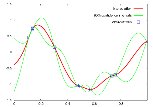 Figure 1. Example of one-dimensional data interpol...
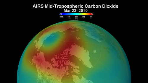 Arctic Carbon Dioxide, March 23, 2010
 Arctic Carbon Dioxide, February 2010 to February 2...
For comparitive purposes the majority of the parameters have been standardised and the default 10 category view of the surfaces used for the interpretation of result.
The point data used for the study was collected in 2002 by the author through the use of a total station and handheld GPS. By predicting several surfaces through various interpolation methods it is hoped to comment on significant differences and similarities produced through the process, commenting on the quantitative and qualitative properties of the data.
The hillslope used for this study resides in the Wiaotahi Valley, an hour east of Tauranga on a platau above the surrounding flood planes. The reason for interest in this area is due to the high erosion and uplift rates that the area suffers from, the hillslope in question has risen...